 Although Prince Edward
Islanders treasure their home and recognize the
uniqueness of their “islandness,” the challenge
of crossing the Northumberland Strait to reach the
mainland has long been an issue. In fact, the Canadian
government was able to persuade Prince Edward Island to
join Confederation in large part by promising to provide
“a continuous means of communication between Prince
Edward Island and the mainland.” During these early
days, there was often talk about a bridge, or even a
tunnel under the Strait, but neither option was
financially viable. Ultimately, and amid great debate and
controversy in the mid-1980s, the federal government
began the process that led to the construction of the
Confederation Bridge.
Although Prince Edward
Islanders treasure their home and recognize the
uniqueness of their “islandness,” the challenge
of crossing the Northumberland Strait to reach the
mainland has long been an issue. In fact, the Canadian
government was able to persuade Prince Edward Island to
join Confederation in large part by promising to provide
“a continuous means of communication between Prince
Edward Island and the mainland.” During these early
days, there was often talk about a bridge, or even a
tunnel under the Strait, but neither option was
financially viable. Ultimately, and amid great debate and
controversy in the mid-1980s, the federal government
began the process that led to the construction of the
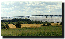
Confederation Bridge. Built by Strait Crossing Inc., bridge construction began in October 1993, and the last span was dropped in place on November 19, 1996. The 12.9-kilometre Confederation Bridge crosses the Northumberland Strait at its narrowest point, joining Borden-Carleton, Prince Edward Island, and Cape Jourimain, New Brunswick. It is the longest bridge over ice-covered waters in the world. The bridge rests on gravity foundation footings on bedrock up to 35 metres in depth. The main bridge components were produced at the 150-acre Staging Facility in Borden-Carleton. Four separate component production areas allowed for the manufacture of main girders, drop-in spans, pier shafts, and pier bases.
Confederation Bridge is estimated to have cost $1 billion to build, somewhat more than the projected $840 million. Strait Crossing will operate the bridge for 35 years, from 1997 to 2032, at which time the bridge becomes the property of the Canadian government. Confederation Bridge is projected to last for 100 years.
The highest point of the bridge is 60 metres above water, located at the Navigation Span, while the average height of the entire structure is 40 metres. From the shore, one notices that the bridge is not straight but curved. It was designed this way in order to ensure that drivers remain attentive and thus reduce the potential for accidents that, according to experts, happen more often on straight highways or bridges. For these same reasons of safety, vehicles are not permitted to stop or pass other vehicles while on the bridge.
 The
bridge opened on May 31, 1997, and carries 2 lanes of
traffic 24 hours a day, 7 days a week. Drivers travelling
at normal speeds (80 kilometres per hour) can cross the
bridge in approximately ten minutes. However, the speed
limit is dropped when weather conditions dictate. During
the winter, high winds across the strait can be dangerous
enough to cause traffic restrictions, closing the bridge
to large trucks, recreational vehicles, and buses. Cars
are often still able to cross because they are protected
by the 1.1-metre high concrete barriers on the bridge
that act as a windbreak while preventing drivers from
seeing directly over the side.
The
bridge opened on May 31, 1997, and carries 2 lanes of
traffic 24 hours a day, 7 days a week. Drivers travelling
at normal speeds (80 kilometres per hour) can cross the
bridge in approximately ten minutes. However, the speed
limit is dropped when weather conditions dictate. During
the winter, high winds across the strait can be dangerous
enough to cause traffic restrictions, closing the bridge
to large trucks, recreational vehicles, and buses. Cars
are often still able to cross because they are protected
by the 1.1-metre high concrete barriers on the bridge
that act as a windbreak while preventing drivers from
seeing directly over the side. Pedestrians and cyclists are not permitted on the Confederation Bridge and must report to the control/transfer facilities at either end of the structure. A shuttle bus transports these travellers across the bridge on demand, with a maximum two-hour wait. A wheelchair lift equipped vehicle is also available.