 In 1871, Prince Edward
Island’s colonial government undertook the
construction of a railway connecting the communities of
Alberton and Georgetown. Branches linked the communities
of Souris and Tignish to the main line and, eventually,
every community on the Island wanted a branch line to
their locality. As a result, the tracks zigzagged across
the territory and cost much more than expected, dragging
the colony into debt. Only Britain would lend the Island
money, but on the condition that the colony join the new
country of Canada. The railway, thus, was a key
contributor to the Island joining Confederation in 1873.
In 1871, Prince Edward
Island’s colonial government undertook the
construction of a railway connecting the communities of
Alberton and Georgetown. Branches linked the communities
of Souris and Tignish to the main line and, eventually,
every community on the Island wanted a branch line to
their locality. As a result, the tracks zigzagged across
the territory and cost much more than expected, dragging
the colony into debt. Only Britain would lend the Island
money, but on the condition that the colony join the new
country of Canada. The railway, thus, was a key
contributor to the Island joining Confederation in 1873. In 1994, five years after the Prince Edward Island railway was shut down, the provincial government purchased the former rail lands from Canadian National Railways and converted it to the trail that was to become known as the Confederation Trail. Although not all landowners support the idea of public recreational use of these lands, approximately half of this 450-kilometre corridor has been developed into world-class hiking, cycling, and snowmobile trails for tourism and recreation. Non-profit community organizations engage in short-term leases to develop the trail.
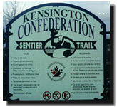 The Confederation
Trail is part of the country-wide Trans-Canada Trail
system, the longest trail of its kind in the world,
spanning approximately 15,000 kilometres. The trail
provides opportunities for recreation and outdoor
enjoyment, as well as an alternative travelling route and
mode of transportation between Island communities. The
Confederation Trail leads hikers, cyclists,
snowmobilists, and horseback riders through farmlands and
woodlots and along waterways. Journeying from one Island
community to another, travellers can enjoy many amenities
including, for example, campgrounds, bed and breakfasts,
restaurants, stores, heritage sites, and tourist
attractions. Many communities also have parking
facilities near trail-road junctions for those only
interested in short jaunts along the trail.
The Confederation
Trail is part of the country-wide Trans-Canada Trail
system, the longest trail of its kind in the world,
spanning approximately 15,000 kilometres. The trail
provides opportunities for recreation and outdoor
enjoyment, as well as an alternative travelling route and
mode of transportation between Island communities. The
Confederation Trail leads hikers, cyclists,
snowmobilists, and horseback riders through farmlands and
woodlots and along waterways. Journeying from one Island
community to another, travellers can enjoy many amenities
including, for example, campgrounds, bed and breakfasts,
restaurants, stores, heritage sites, and tourist
attractions. Many communities also have parking
facilities near trail-road junctions for those only
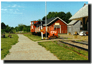
interested in short jaunts along the trail. Two major sections of the trail are complete, totalling more than 225 kilometres of rolled stonedust surface. The Western portion of the trail begins at Kensington’s stone railway station, built in 1905 and recognized as a national historic site. The trail winds its way ten kilometres, running parallel to an equestrian trail before reaching the City of Summerside. Further on, travellers can enjoy
 lookout points
at Grand View Bridge in Wellington and the Huntley River
Bridge Viewpoint, north of Alberton. The main trail also
connects with community trails in West Prince—the
Palmyra Trail (to Tyne Valley) and the Ellerslie-Bideford
walking trail. A bog interpretation site is located at
Ellerslie, the Trout River Natural Area and Leard’s
Pond Mill is near O’Leary, and the Train Wreck
Interpretation Site historic monument is along the trail,
just outside Tignish.
lookout points
at Grand View Bridge in Wellington and the Huntley River
Bridge Viewpoint, north of Alberton. The main trail also
connects with community trails in West Prince—the
Palmyra Trail (to Tyne Valley) and the Ellerslie-Bideford
walking trail. A bog interpretation site is located at
Ellerslie, the Trout River Natural Area and Leard’s
Pond Mill is near O’Leary, and the Train Wreck
Interpretation Site historic monument is along the trail,
just outside Tignish. The Eastern portion of the Confederation Trail begins at Mount Stewart, near the head of the Hillsborough River, which was designated a Canadian Heritage River in 1997. Between Morell and the community of St. Peter’s, the trail crosses three rivers: the Morell, the Marie, and the Midgell. Each bridge offers a breathtaking vista of the rivers as they spill into St. Peter’s Bay. The Greenwich sand dunes, the newest addition to the Prince Edward Island National Park, can be seen across the Bay and observant hikers and cyclists will spot Great Blue Heron, Kingfishers, and perhaps even a Bald Eagle along the shores. Beyond St. Peter’s, woodlands and wetlands dominate the areas surrounding the trail and, on higher ground, the hardwood forests are home to grouse, foxes, and owls. At the end of the trail, in Elmira, the old station house has been restored and serves as a railway museum.
The map on the Home Page outlines the completed portions of the Confederation Trail.