
Tunnels of sugar maple, red maple, beech, and red oak, bordered by lupins, black-eyed Susans, daisies, and Queen Anne’s lace... Prince Edward Island’s heritage roads are delightful pathways to the Island’s rural past. These red clay, sun-dappled roads bordered by wildflowers and native shrubs twist along fields and through wooded hills. In their day, they were commonly travelled roads between communities, connecting farms to sawmills and furniture factories. Having escaped asphalt paving, these clay lanes and their surrounding vegetation are now protected from alteration. Island wildlife also enjoy these roads which serve as corridors for foxes, squirrels, and snowshoe hares and as nesting areas for song birds. The Island’s heritage roads constitute a cultural and natural heritage unto themselves.
 In Prince Edward
Island, scenic heritage designation of roads became
possible in 1987. Under the Planning Act regulations,
individuals are prohibited from cutting or removing
trees, shrubbery or plant life or in any way altering the
landscape of a scenic heritage road without written
permission from the minister responsible for the
environment. There are sixteen heritage roads across the
Island: three in Prince County, nine in Queens County,
and four in Kings County.
In Prince Edward
Island, scenic heritage designation of roads became
possible in 1987. Under the Planning Act regulations,
individuals are prohibited from cutting or removing
trees, shrubbery or plant life or in any way altering the
landscape of a scenic heritage road without written
permission from the minister responsible for the
environment. There are sixteen heritage roads across the
Island: three in Prince County, nine in Queens County,
and four in Kings County.
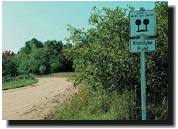
Prince County |
Queens County |
Kings County |
“John
Joe” Road |
Millman Road |
County Line
Road |
The John Joe Road, also known as the
Hackney Road, travels 2 kilometres from Route 142 (the
Kelly Road) to Route 136, near Mill River Resort in
western Prince County. With grain fields and potato
fields alternating with woodland, travellers along the
road journey through a representative Island rural
landscape. A past resident of the road, John Joe
Gallant’s name has long been associated with this
lane. A Mr. Hackney, the road’s other namesake was
apparently involved in the road’s construction in
1912–1914. Until Hackney’s work, there was
little ‘road’ to speak of, consisting only of a
cart track leading to a homestead in the wood. Near the
southern end of the road, vestiges of an old stagecoach
road can be found leading from Kelly Road toward
Alberton.
The County Line Road, in the
Darnley-Sea View area near Kensington, is a relatively
straight but hilly stretch of road running south for 4.5
kilometres from Route 103 to Route 101. Travelling
through open farmland and mixed woodland, the road leads
up a high 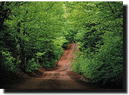 “magnetic” hill to
a summit offering a spectacular view of the Gulf of St.
Lawrence to the north and the Island’s rolling hills
to the south. Beyond its natural beauty, the County Line
Road provides a fascinating peek into a piece of Island
history. The hill is apparently so steep at its base
that, in the days of yore, a wagon driver with a full
load of grain could touch the ears of his horses while
sitting in his seat. Undeterred by the risk to their
precious cargo, it is also said that rumrunners would
travel the secluded County Line Road when headed toward
Kensington.
“magnetic” hill to
a summit offering a spectacular view of the Gulf of St.
Lawrence to the north and the Island’s rolling hills
to the south. Beyond its natural beauty, the County Line
Road provides a fascinating peek into a piece of Island
history. The hill is apparently so steep at its base
that, in the days of yore, a wagon driver with a full
load of grain could touch the ears of his horses while
sitting in his seat. Undeterred by the risk to their
precious cargo, it is also said that rumrunners would
travel the secluded County Line Road when headed toward
Kensington.
One of the most famous early roads, the Princetown Road
dates to 1771, at which time it connected Charlottetown
to Princetown (now Malpeque), the original capital of
Prince County. The Warburton Road, forming a
“Y” with the Princetown Road, dates to 1898.
Winding its way 7.8 kilometres through steep hills, along
woodlands, hedgerows, and farmlands, the
Princetown-Warburton Road offers spectacular views of the
Island’s patchwork of fields. Locals’
familiarity with their community’s hills and valleys
has engendered the creation of local names for particular
spots. Along this road, one will come across “Inch
Hill,” “Burnt Hill,” and
“Marianne’s Hollow.”
Jack’s Road, near Wood Islands, on the Island’s
south shore winds 4 kilometres from Route 1 to Route 207.
The lane acquired its name from Islanders frequently
travelling to Jack MacPherson’s home in the early
1900s. The winding narrow road is bordered by hemlock,
sugar maple, beech, and birch. In summer and fall, these
trees in full leaf form a majestic archway over the
sun-dappled clay.

National Park
| Historic Sites
| Museums and
Historic Villages
Historic
Buildings and Churches | Monuments
to Our Past